Over the Top
 |
| Heading from Leh towards Kardungla |
21st April 2017
I awoke to a clear morning and views of the
mountains, which rapidly disappeared under cloud.
As I was packing up (and doing a bit of
blog uploading as wifi was working on my laptop in the morning), Rigu knocks on
my door to say that while he said we would leave at 8:30am, it would be better
to leave at 8am. I am bemused at
the advance notice. It was, at
that time, about 7:55am.
 |
| Preparing to put the chains on |
I complete formalities at the hotel,
including a check in form that wanted to know what colour my grandmother
painted her toenails on her wedding night (well, almost) and I was offered the
front seat in the car to better enjoy the views – good, I was hoping for that
and was going to ask if it were not offered.
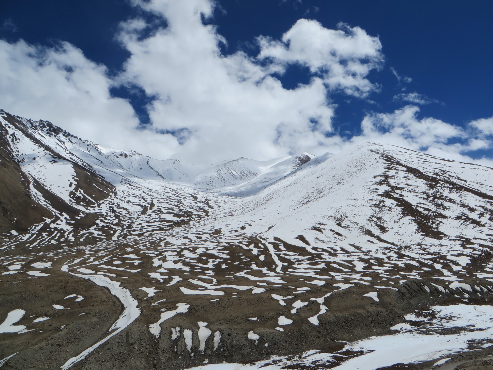
30 minutes out of town we encountered the
snowline and the amount of snow on the road increases gradually as we get
higher, as does the amount of snow falling.
 |
| The first major hold up |
Rigu inquires about the presence of
otherwise of headache at regular intervals. Given that I had woken with symptoms of a budding cold, it
was hard to distinguish possible altitude issues from cold related symptoms. However, plenty of water and some
ibuprofen kept the headache to no more than a background suggestion.
A conversation about medical facilities and
schools confirms that all are provided to all communities, no matter how remote. And nomads have “tent school” – 2
teachers assigned to a band of nomads to teach their primary age children. That, it seems, is not the most popular
post one can get. There are
several such postings throughout Ladakha.
 |
| On the top! 18,380ft according to the sign |
At the first checkpoint (present road
permits and passport – this is an army owned road) we are about 4,600m above
sea level.
From here on the road is only cleared to be
suited for one-way traffic, so the checkpoint will close at this end at
11am. After that it will be army
vehicles only, then the checkpoint at the other end will open at 2pm to
vehicles travelling to Leh.
A small queue of vehicles is pulled over
for the road permit checks is required of all, as well as fitting chains –
no vehicles are allowed past this point without chains fitted. The chains are the ladder style chains,
ex army, and are secured with many lengths of rope or string – many of which do
not look particularly strong.
The fitting of chains takes a long time, so
I head off to find a toilet.
Following directions (and vehicle tracks) in the indicated direction I
manage to unceremoniously slip and land on my rear end. Walking on untracked
snow is a better option. I
finally reached the building marked ladies urinal (one wonders where one was
supposed to go if in need of more than this) and spent a good 5 minutes
attempting to open the door, which was snowed closed.
 |
| There IS road out there somewhere! |
Eventual success (well, partial – to the point where I could
enter) revealed the very basic facility of a wooden board, with a hole in the
middle, and nothing but the open air and ground below. A traditional toilet. The adjacent gents
facility, with its porcelain urinal was in full view as the dividing wall had
long ceased to exist. Hoping that no
one was about to attempt to make use of that facility, I proceeded and then returned
to the car. Rigu later told me that tourists have been known to
accidentally drop all sorts of valuable items down such facilities – purses,
passports …..
Further tying and fitting of the chains was
still in progress and I had a quick chat with a couple of young Indonesian men
who expressed astonishment that I should be travelling alone – if travelling
with a guide and driver constitutes “alone” They also told me they were travelling with other
family members who were so affected by altitude sickness that they had remained
in Leh.
 |
| The cloud starts to lift as we head down the other side of Kardungla |
Eventually an adequate number of ropes had
been threaded and knots tied to secure the chains and we proceeded to the barrier,
which someone eventually came to raise for us. “Please officer, would you raise the barrier” was, of
course, executed by a toot of the horn.
 |
| And eventually we are towards the bottom of the snow line |
We proceeded at a suitably slow pace for a
while – the cloud conditions were such that the road seemed largely defined by
the snow ploughed walls on each side – then were stopped by a stationary
vehicle in front of us. This
happened 3 times. Each stop
consuming quite some time. To cut
a long story short, there were 3 cars ahead of us that did not have chains –
and they weren’t even 4 wheel drive vehicles. Another 2 vehicles had one chain each. It was taking a fair bit of manpower to
get them unstuck from whatever predicament they had managed to get into.
On the third occasion, Rigu suggested they
should pull to one side so the vehicles with chains could get through. This was not a popular request as it
would remove much of the manpower to keep these vehicles moving – however
nothing was going to get easier for them until they were well over the pass,
and that was some time yet. The
words “rude” and “Muslim” and “arrogant” or similar were used in juxtaposition
by Rigu a number of times.
 |
| Perhaps evidence of much greater water flow in the past |
We finally passed the offending vehicles
and continued slowly to the pass, Kardungla reputed to be 18360ft and the
highest (or second highest) motorable road in the world. High 5! I had done it without oxygen. We stopped briefly, in worsening weather conditions, for a
quick photo and toilet stop. I was
taken around the side of a building (assuming a toilet – assume nothing!) and
pointed towards a patch of snow.
Since it had taken a fair effort to get there and the few people around
appeared to be heading in other directions, I proceeded and returned to the
car.
 |
| Beware: Yaks crossing! |
I was sufficiently compos mentis on the pass to take my
empty plastic 2 litre water bottle and screw the lid on tightly for one of my
favourite air pressure experiments – as much for my amusement as anyone
else’s. Once we were back down at
10,000ft the bottle was well and truly compressed – having lost well over half
its volume. Must be nerdy and do
the maths on that!
We declined stopping for tea, due to the
worsening weather, and proceeded in near whiteout conditions. How Bublo could actually see where to
go rather defeated me!
 |
| Spring is here - apricot tree in bloom |
We did have a few interesting little
slides, but eventually got to more manageable conditions, removed the chains,
and descended below the cloud line into a stunning valley.
A roadside café provided lunch of momo – a
plate of momo was more than I could eat but assistance with finishing then was
gladly provided. I imagine this is
an area where food is definitely not to be wasted, especially at the end of
winter when the land is so dry.
There was a further short delay while Bublo
negotiated the purchase of a small container of fuel – black market, ex army,
maybe?
 |
| Rock flow from floods |
The scenery as we proceeded on our journey
is stunning; valleys and chasms suggestive of much more water flow in the past
Herders pass with their sheep, goats, yak
& zho, one such herd providing a short road block and an opportunity for me
to get out to take photographs.
The Yak are much smaller than those I saw in Bhutan – perhaps stunted
due to insufficient food on a repeated seasonal basis.
The Nubra valley is slightly lower than
Leh, and spring is considerably more advanced, with apricot trees in flower and
apple trees starting to show their leaves. This valley was part of the Silk Road in times gone past.
 |
| Terisha Tso |
The river that flows through the valley is
the most gorgeous shade of blue-green.
We pass by (and through) big flows of rock
debris which are the result of floods in 2010 – produced by cloudbursts. Unusual weather, possibly attributable
to climate change.
We divert into a side valley visit to
Samtenling Monastery in the village of Sumur. After that we continue to some hot springs – around which a
facility had been built with showers and a small pool – I bathed for a short
time in the pool. The water is
supposed to be good for joints – While I don’t expect it to cure my arthritis
overnight, I can hope it does some good.
 |
| The dust starts to obscure the view |
From there we visited the little sacred
lake Terisha Tso, sacred because many people have seen in it images of Buddha,
Tara, or other gods. It is in a
lovely setting and there are a few migratory ducks settled in for the summer.
As we leave the lake to walk back to the
car, the wind picks up at our back and brings with it a bit of a dust
storm. The dust worsens as we head
back down the valley, and obscures not only the immediate scenery but also the
mountain peaks in some directions.
Apparently the wind is normal for late afternoons – and the dust with
it.
 |
| The main room of my tent |
I did have to ask where the water drained
if I were to use the shower – of course, silly of me not to assume that it had
to run half way across the floor to a hole beside the sink.
Dinner that night was good, but way too late
for my body clock!
 |
| The enclosed verandah of my tent |
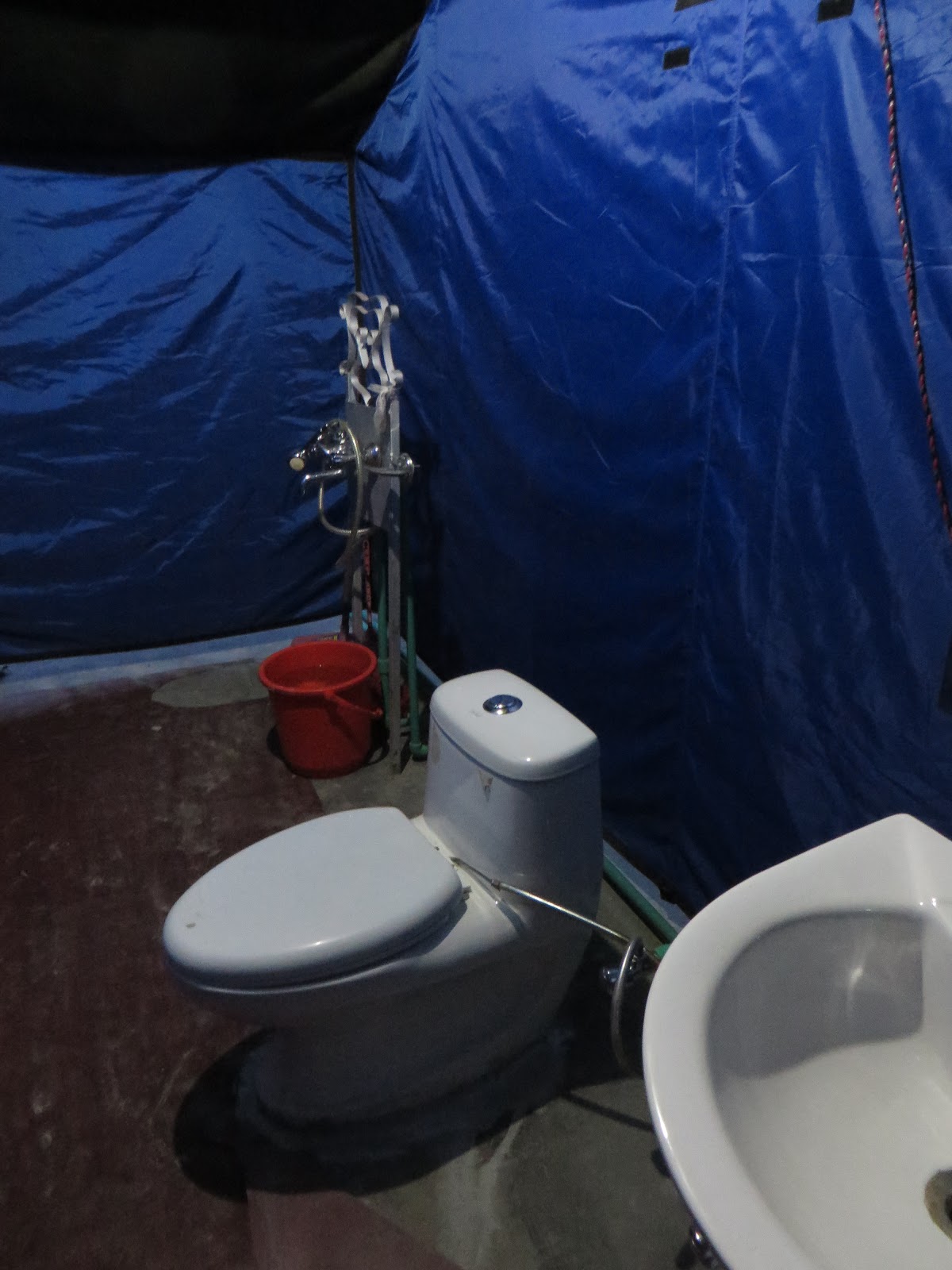 |
| The bathroom in my tent |


Comments
Post a Comment